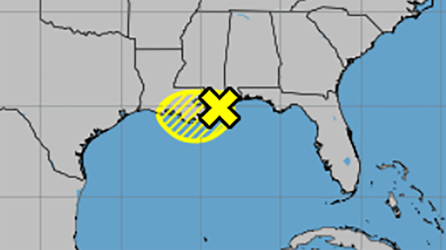
A tropical disturbance in the Gulf of Mexico is bringing heavy rain to Louisiana and Mississippi, but forecasters don’t believe it will strengthen into anything significant.
“It’s going to be a minor nuisance. Street flooding could possibly be the biggest issue with this storm. That’s something we’ll clearly have to watch,” LSU Public Health Climatologist Barry Keim told Louisiana Radio Network.
At 1 p.m. CT Thursday, the system was moving inland over southeastern Louisiana. It has a low chance of developing into a tropical depression as it lingers near the coast on Thursday, and is expected to weaken further as it moves inland on Friday.
Parts of southeastern Louisiana, including Baton Rouge and New Orleans, remain under a flood watch until Friday. Other areas like Lafayette remain under the watch through Saturday morning.
Rainfall predictions
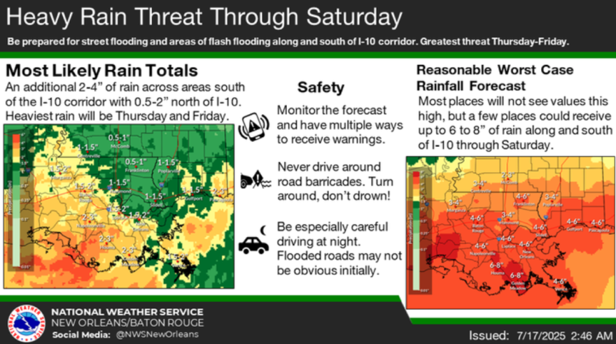
Louisiana is already experiencing heavy rain from the disturbance and this will continue through at least Friday. The National Weather Service lowered rainfall predictions for the region. They’re expecting an additional 0.5 to 2 inches for areas north of the Interstate 10/12 corridor, and 2 to 4 inches to the south. Some areas south of I-10 could see up to 8 inches through Saturday.

Risk of flooding
Baton Rouge and New Orleans remain under a flood watch until late Friday night. Other areas, including Lafayette, remain under the watch until Saturday morning. The National Weather Service said the risk for excessive rainfall and flash flooding is highest on Thursday and Friday for areas along and south of the I-10/12 corridor. The risk on Saturday depends on the amount of rain that falls earlier in the week.
Heavy rainfall could lead to ponding in low-lying and poorly drained areas, with some roads potentially becoming impassable. Residents are being urged to avoid driving through floodwaters.
Storm response
In a press release, Mayor-President Sid Edwards’ office said that the City-Parish Department of Works (DPW) was preparing for the storm and inspecting and clearing drainage systems. Crews were reassigned from their regular duties to focus on storm prep.
The Baton Rouge Fire Department said it had inspected all emergency equipment and placed Swift Water Rescue teams on standby.
Entergy said it’s closely monitoring the disturbance and is ready to respond to any outages with crews, materials and other resources in place.
“As we begin to put our plans into place, we are urging our customers to take the potential of severe weather seriously and stay prepared,” said Shelton Hudson, vice president of reliability for Entergy in Louisiana. “Now is not the time to let your guard down – please take the necessary steps to ensure the safety of your family and your home.”
The Mayor’s Office of Homeland Security and Emergency Preparedness (MOHSEP) has restocked sandbag locations with more sand and bags. Residents must bring their own shovels.
The locations are:
- BREC Airline Highway Fairgrounds
- BREC Alsen Park
- BREC Baker Park
- BREC Cadillac Street
- BREC Doyles Bayou Park
- BREC Flannery Road Park
- BREC Hartley-Vey at Gardere Park
- BREC Lovett Road Park
- BREC Memorial Stadium
MOHSEP also plans to deliver 10 pallets of pre-filled sandbags to the East Baton Rouge Council on Aging (COA) to be distributed to seniors. The facilities will close in the afternoon to ensure seniors can travel in safer conditions. Pre-filled sandbags will also be available for pickup at the Lotus Center, 1701 Main Street, until supplies run out. The City-Parish doesn’t charge residents for sandbags, so be vigilant about scams at sandbag sites.
“Our top priority is protecting life and property,” said Mayor Edwards. “We are taking every precaution to minimize the impacts of this storm, and we ask residents to join us in being prepared and staying alert.”
For storm preparation tips, emergency alerts, and more information, Baton Rouge residents can visit brla.gov/redstickready or download the Red Stick Ready mobile app.


