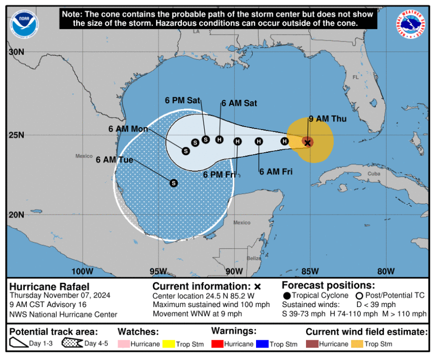
Hurricane Rafael is losing strength in the Gulf of Mexico after hitting Cuba as a Category 3 storm Wednesday, knocking out the entire country’s power grid.
The forecast cone no longer includes Louisiana. Local impacts will be primarily coastal flooding, winds and heavy rainfall from the system’s outer bands, the National Weather Service said.
At 9 a.m. Thursday, Rafael was about 200 miles west-northwest of Havana, Cuba and 215 miles west of Key West, Florida, packing maximum sustained winds of 100 mph. It was moving west-northwest at 9 mph with hurricane-force winds extending outward up to 30 miles from the storm’s center.
The system is forecast to continue to weaken as it moves west over the Gulf of Mexico. An increasing vertical wind shear over the Gulf is expected to slow its intensification and lead to weakening.

Louisiana has a small chance of seeing tropical storm strength winds from outer bands of the storm this weekend, according to state climatologist Jay Grymes.
“The NHC (is) still showing 10% chance of (tropical storm) winds along the coast,” Grymes said in a statement. “Even 10% seems too high.”
There is a slight risk for excessive rainfall on Saturday due to a frontal system meeting up with some moisture from the hurricane. Communities east of Highway 171 and north of Interstate 10, including Baton Rouge, have the highest chance of seeing up to 4 inches of rain over the weekend, according to the NWS.
Rafael is expected to dump 2 to 4 inches of rain across parts of western Cuba on Thursday, which could lead to flash flooding and mudslides, especially along higher terrain, according to the National Hurricane Center.
Swells from the storm will spread across the Gulf and could cause life-threatening surf and rip current conditions, the NHC said.
There were no coastal watches or warnings in effect at 9 a.m. CT Thursday.
Rafael is the 17th named storm of the Atlantic hurricane season, which lasts until Nov. 30. The next named storm of the season would be Sara.


