


(Versión en español abajo)
Hurricane Isaias made landfall in the western Florida Panhandle on Friday, October 9, 2026, at 8:30 p.m. Central Time, near Destin, Florida. Isaias made landfall with maximum sustained winds of 105 mph, making it a Category 2 hurricane, and a minimum central pressure of 971 millibars.
Overnight, the storm will continue moving northward, gradually picking up speed and bringing torrential rainfall to parts of the Florida Panhandle. Wind shear has shifted the deepest convection east of the storm's center. As a result, the heaviest rainfall is expected across the Florida Panhandle, southeastern Alabama, and southwestern Georgia.
The Carolinas will also see torrential rainfall on Saturday, with gusty southeasterly winds. Some embedded thunderstorms could become severe. The Storm Prediction Center has placed much of Georgia and southern South Carolina under a risk of severe thunderstorms. The primary threat will be tornadoes, which could affect large portions of the central Florida Panhandle, central and southern Georgia, and South Carolina throughout Saturday as thunderstorms embedded within Isaias' rainbands move across the region.
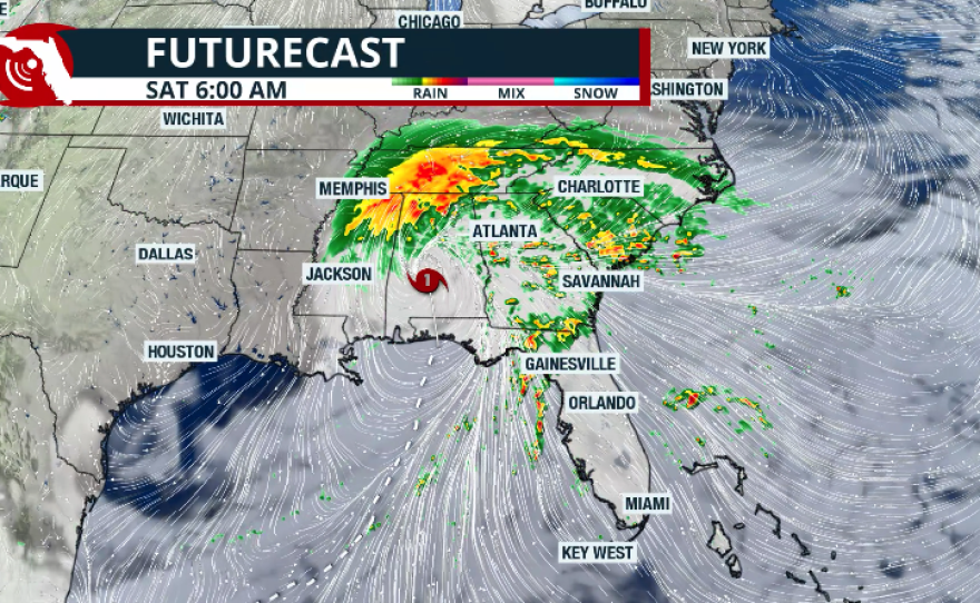
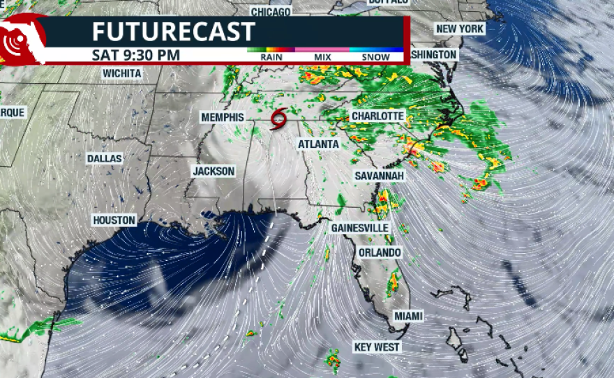
Some locations along the Florida Panhandle could receive up to 15 inches of rainfall. Widespread rainfall totals of 2 to 4 inches are expected across much of Georgia, with isolated areas potentially receiving up to 6 inches. The flash flood threat will persist throughout Saturday. Through Saturday morning, parts of southern Alabama, southwestern Georgia, and the Florida Panhandle remain under a moderate risk of flash flooding. Between Saturday and Sunday, the moderate risk of flash flooding will extend into the Atlanta metropolitan area, through Upstate South Carolina, and along the eastern slopes of the Blue Ridge Mountains.

Longer-range forecast models show the remnants of Isaias continuing through the Mid-Atlantic region on Sunday and likely reaching the southern Northeast by Sunday night. Gusty winds and heavy rainfall could affect the Tri-State area, with unsettled conditions extending farther north. As Isaias weakens, its sustained winds will gradually diminish. However, its rainbands could still produce damaging wind gusts. Some embedded thunderstorms may generate wind gusts of up to 60 mph as they move through the region.
Tornadoes will remain a significant threat across portions of the Southeast. The Storm Prediction Center has issued another tornado watch for parts of southeastern Alabama, southern Georgia, and the Florida Panhandle extending over North Florida until 6 a.m. Saturday.

A few tornadoes are possible overnight and into Saturday morning. Remember, a tornado watch means conditions are favorable for tornadoes and severe thunderstorms to develop in and near the watch area.
Please keep your weather alerts enabled throughout the night. Nighttime tornadoes are especially dangerous because they're harder to see, and people may be asleep when warnings are issued.
Stay weather-aware and have multiple ways to receive warnings as the storm continues moving inland.
Our thoughts are with the communities facing Hurricane Isaias and the first responders helping them.
— Hurricane Hunters (@53rdWRS) October 10, 2026
This footage offers a view from the Air Force Reserve Hurricane Hunters’ mission into the storm, where crews collected weather data to support National Hurricane Center… pic.twitter.com/THvvpzAAmM
—————————————————-
(Spanish version)
El huracán Isaias toca tierra en el noroeste de Florida, dejando fuertes lluvias y la amenaza de tornados.
El huracán Isaias tocó tierra en el sector occidental del noroeste de Florida el viernes 9 de octubre de 2026, a las 9:30 p. m., hora del centro, cerca de Destin, Florida.
Isaias tocó tierra con vientos máximos sostenidos de 105 millas por hora, lo que lo convierte en un huracán de categoría 2, y una presión central mínima de 971 milibares.
Durante la noche, el sistema continuará desplazándose hacia el norte, aumentando gradualmente su velocidad de traslación y provocando lluvias torrenciales en sectores del noroeste de Florida. La cizalladura del viento ha desplazado la actividad convectiva más intensa hacia el este del centro de la tormenta. Como resultado, se esperan las precipitaciones más intensas en el noroeste de Florida, el sureste de Alabama y el suroeste de Georgia.
Las Carolinas también recibirán lluvias torrenciales durante el sábado, acompañadas de vientos fuertes y ráfagas provenientes del sureste. Algunas tormentas eléctricas inmersas en las bandas de lluvia podrían alcanzar intensidad severa.
JUST IN: Saildrone Explorer SD-1045 passed through the eye of Category 3 Hurricane Isaias, recording wind gusts over 90 knots (103 mph).
— Saildrone (@saildrone) October 9, 2026
This is the same USV that filmed inside Hurricane Sam in 2021, setting a Guinness World Record.
Watch ↓ @NOAA_AOML @noaapmel pic.twitter.com/4i6BFscUFn
El Centro de Predicción de Tormentas (SPC, por sus siglas en inglés) ha colocado gran parte de Georgia y el sur de Carolina del Sur en riesgo de tormentas eléctricas severas. La principal amenaza serán los tornados, que podrían afectar amplias zonas del centro del noroeste de Florida, el centro y sur de Georgia, así como Carolina del Sur, durante el sábado, a medida que las tormentas eléctricas asociadas con las bandas de lluvia de Isaias avancen por la región.
En algunas localidades del noroeste de Florida podrían acumularse hasta 15 pulgadas de lluvia. En gran parte de Georgia se esperan acumulaciones generalizadas de entre 2 y 4 pulgadas, mientras que algunos sectores aislados podrían recibir hasta 6 pulgadas.
La amenaza de inundaciones repentinas continuará durante todo el sábado. Hasta la mañana del sábado, se mantiene un riesgo moderado de inundaciones repentinas en sectores del sur de Alabama, el suroeste de Georgia y el noroeste de Florida. Entre el sábado y el domingo, el riesgo moderado de inundaciones repentinas se extenderá hacia el área metropolitana de Atlanta, el norte del estado de Carolina del Sur y las laderas orientales de las montañas Blue Ridge.
Los modelos meteorológicos a más largo plazo indican que los remanentes de Isaias continuarán avanzando por la región del Atlántico Medio durante el domingo y probablemente alcanzarán el sector sur del noreste de Estados Unidos durante la noche del domingo. Los vientos con ráfagas fuertes y las lluvias intensas podrían afectar el área triestatal, mientras que las condiciones meteorológicas inestables se extenderían hacia zonas más al norte.
A medida que Isaias pierda intensidad, sus vientos sostenidos disminuirán gradualmente. Sin embargo, sus bandas de lluvia todavía podrían producir ráfagas de viento capaces de causar daños. Algunas tormentas eléctricas inmersas en estas bandas podrían generar ráfagas de viento de hasta 60 millas por hora mientras atraviesan la región.
8:33 pm en proceso de entrada el ojo del huracán #Isaias. La pared norte tiene vientos estimado por radar Mobile sobre 120 mph. Esté en habitación segura. pic.twitter.com/nmrd37pZ1Q
— Ada Monzón (@adamonzon) October 10, 2026
Los tornados continuarán representando una amenaza importante en el sureste de Estados Unidos. El Centro de Predicción de Tormentas ha emitido una nueva vigilancia de tornados para sectores del sureste de Alabama, el sur de Georgia y el Panhandle de Florida hasta el norte de Florida, vigente hasta las 6:00 a. m. del sábado.
Existe la posibilidad de que se formen varios tornados durante la noche y hasta la mañana del sábado.
Recuerde que una vigilancia de tornados significa que las condiciones atmosféricas son favorables para el desarrollo de tornados y tormentas eléctricas severas dentro y cerca del área bajo vigilancia.
Por favor, mantenga activadas las alertas meteorológicas en sus dispositivos durante toda la noche. Los tornados nocturnos son especialmente peligrosos porque resultan más difíciles de detectar visualmente y muchas personas podrían estar durmiendo cuando se emitan las advertencias.
Manténgase atento a las condiciones del tiempo y asegúrese de contar con varias formas de recibir alertas meteorológicas mientras el sistema continúa avanzando tierra adentro.
Copyright 2026 Storm Center